FIELD: geophysics.
SUBSTANCE: invention is intended for forecast of crust earthquakes and location of regions of seismic-ionospheric interactions in seismically active regions of the Earth in long-wave range of radio waves, for which earthquakes with amplitude M > 4 are distinctive. Network of radio routes covering seismically risky zone is formed. Radio routes crossing several times form grid of cells with cross-sections comparable with cross-sections for priority regions of zone. Coded burst of coherent radio pulses is periodically emitted by format specified per each of M points (M>1) on carrier in LW range of radio waves, phase of each burst in each radio pulse changes in accordance with prescribed code. Filtration of additive mixture of signals carried by surface and spatial waves is conducted in each of N reception points (N>2) along each route coordinated with corresponding format. Delays of signal of spatial wave relative to time of reception of signal of surface wave are measured many times. Anomalous delays which absolute deviations from reference value exceed specified value are recorded and identified. Time and duration of their manifestations are recorded. In addition disturbed routes for which alternation of regular and anomalous delays is characteristic are brought to light. If time intervals between more than three anomalous delays recorded in sequence in time on one or several disturbed radio routes crossing at least two other radio routes with anomalous delays shorten consistently judgment on possible region of earthquake can be made. Date of earthquake is then computed by formula 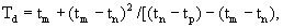 where
where  is data of m-th manifestation of anomalous delay, m being natural number, m>2, n =m-1, p=n-1,
  For time interval
  assemblage of spatially disturbed routes including at least one radio route with consistently diminished time interval between at least three anomalous delays and radio routes on which anomalous delays are recorded is isolated in addition. Maximal values of delay defines epicenter of supposed earthquake. Facility includes M>1 radio transmitters and N>2 radio receiving measuring and computation complexes integrated in network by communication channels and coupled to center of radio wave earthquake forecasting center.
EFFECT: increased accuracy and authenticity of prediction of point and time of earthquake.
2 cl, 4 dwg
| Title | Year | Author | Number |
|---|---|---|---|
| METHOD AND DEVICE FOR RADIOWAVE PREDICTION OF EARTHQUAKE | 1994 |
|
RU2037162C1 |
| RADIO DEVICE FOR DETECTING EARTHQUAKE HARBINGERS | 2004 |
|
RU2256201C1 |
| METHOD OF FORECASTING HIGH-MAGNITUDE CRUST EARTHQUAKES | 2009 |
|
RU2430388C2 |
| METHOD OF ADAPTIVE RADIO COMMUNICATION AT REMOTE RADIO PATHS IN HF RANGE | 2011 |
|
RU2479125C1 |
| METHOD FOR TRANS-EQUATORIAL RADIO COMMUNICATION IN DECAMETRIC RANGE | 2006 |
|
RU2323524C1 |
| PROCESS OF PREDICTION OF LOCATION AND INTENSITY OF EARTHQUAKE | 1998 |
|
RU2150717C1 |
| METHOD OF PREDICTING EARTHQUAKES | 2004 |
|
RU2273869C1 |
| METHOD FOR PREDICTING EARTHQUAKE PARAMETERS | 2003 |
|
RU2256199C2 |
| METHOD OF MONITORING REGION WITH NETWORK OF SEISMIC STATIONS | 2011 |
|
RU2463627C1 |
| METHOD OF PREDICTING EARTHQUAKES | 2005 |
|
RU2309438C2 |

