FIELD: physics.
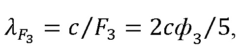
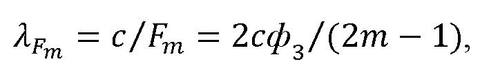
SUBSTANCE: invention relates to oceanographic research, in particular to acoustic methods and instruments for measuring and recording three-dimensional picture of currents in a layered marine medium, as well as characteristics of surface disturbances in the coastal water area. Novelty in the acoustic method of measuring motion parameters of a layered marine medium on a coastal water area is: installation on the bottom surface of the coastal water area of eight peripheral PAHs around the available PAHs, so that the latter becomes the centre of the spatial structure of a square shape, the lengths of the sides of which are equal to the double depth of the reservoir, the location of the peripheral - tops and the middle of the opposite sides, and the directions connecting them, corresponded to the eight-pointed compass rose corresponding to the eight directions of the main winds, - north (N), 0° (360°); north-east (NE), 45°; east (E), 90°; south-east (SE), 135°; south (S), 180°; south-west (SW), 225°; west (W), 270°; north-west (NW), 315°, wherein for all PAHs, projections of surface axial meridians are set uniformly relative to cardinal points, wherein the PAHs are electrically connected to each other and are controlled through the onshore station equipment, which alternately realizes two bistatic sounding circuits for measuring parameters of sea disturbance in the coastal water area over a spatial structure due to irradiation from bottom to top at a given angle ΘD inclination relative to horizon sections of agitated water-air interface, location of which on water surface correspond to mutually perpendicular directions, as the main winds - north (N), 0° (360°) - south (S), 180°; east (E), 90° - west (W), 270°, and half-winds - north-east (NE), 45° - south-west (SW), 225°; south-east (SE), 135° - north-west (NW), 315° respectively; implementation in the coastal post equipment of the mode of sea disturbance parameters measurement on the coastal water area over the spatial structure due to the upward irradiation at the specified angle ΘD is inclination relative to horizon of four sections of agitated water-air interface in accordance with clause 35 for bistatic sounding scheme at given directions of main winds - north (N), 0° (360°) - south (S), 180° and east (E), 90 ° - West (W), 270°, that is along lines that connect the middle of the opposite sides of the flat spatial structure of the square shape; selection of four reversible EAP located at the intersections of a given parallel and two mutually perpendicular meridians of the hemispherical surface of the central bottom PAH, for which the acoustic axes have the same inclination angles ANDD= 45° relative to the horizon and are in two vertical mutually perpendicular planes passing through the symmetry axes of five bottom PAHs - central and four peripheral, wherein the latter are opposed in pairs relative to the central one; generation of amplitude-pulse modulated electrical oscillations in the radiating channel of the equipment of the central bottom PAA, the envelope of which has a rectangular shape with a carrier frequency f and duration φ3, respectively, and their conversion by means of the selected four reversible EAP of the central bottom PAH into periodic transmissions of ultrasonic waves, performing synchronous start-up in the coastal equipment of the receiving paths of the four peripheral PAHs; formation in aqueous medium of four parametric radiating antennae (FIA), in volumes of which nonlinear sources of formed spectral components are distributed, as a result of which, in particular, low-frequency (LF) ultrasonic signals of multiple frequencies are generated - spectral components with frequencies F1 = 1/2φ3, F2 = 3/2φ3, … FM = (2m − 1)/2φ3 due to the effect of self-demodulation of a pulsed powerful signal with a filling frequency f and a duration of φ3, which propagate in the direction of four mutually perpendicular sections of the agitated water-air interface; installation of acoustic contacts with these four sections of agitated water-air interface, within which a surface wind wave with length and height of irregularities h, which leads to re-emission of LF ultrasonic signals of multiple frequencies; - self-demodulated spectral components with frequencies F1 = 1/2φ3, F2 = 3/2φ3, … FM = (2m − 1)/2φ3, each of the four re-emitted ultrasound fields is a superposition of two components - regular (near the direction of mirror reflection) and random (directions of which cover the entire lower hemisphere), wherein the prevalence of one component over the other makes it possible to unambiguously assess the degree of disturbance of the sea surface; use of reversible EAT, which aperture planes form two-dimensional antenna arrays on irradiated surfaces of four peripheral PAHs, for receiving and converting into electrical signals both reflected and scattered components of re-emitted ultrasound fields from four opposite sections of agitated water-air interface; processing a set of electrical signals from the outputs of the reversible EAT in the (N) channel receiving paths of the equipment, the aperture planes of which form two-dimensional antenna arrays on the irradiated surfaces of the four peripheral PAHs, including filtering at frequencies selected by the operator from the set F1 = 1/2φ3, F2 = 3/2φ3, … FM = (2m − 1)/2φ3 amplification, detection, measurement of amplitude-angular dependencies of sound pressure in reradiated ultrasound fields, i.e. obtaining a normalized distribution, which is determined by the ratio 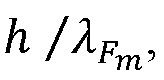 i.e. height of irregularities h of the surface wind wave and wavelengths from the set
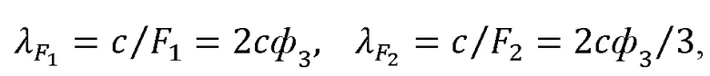
 ...
...  - estimation of the degree of agitation on four opposite sections of the water-air interface due to conversion of the obtained information into a code of indicator elements and interfacing with external recording devices with subsequent display, recording and documentation of measurement results in equipment for first version of bistatic sounding scheme with observance of directions of main winds - north (N), 0° (360°) - south (S), 180°; east (E), 90° - west (W), 270°; performing in the equipment of the coastal post for the mode of measuring parameters of sea disturbance on the coastal water area above the spatial structure due to irradiation from bottom to top at a given angle ΘD of inclination relative to the horizon of four sections of the agitated water-air interface in accordance with paragraph 35 for bistatic sounding scheme at specified directions of half-winds - north-east (NE), 45° - south-west (SW), 225°; south-east (SE), 135° - north-west (NW), 315°.
EFFECT: use of the disclosed method will make it possible to measure and record motion parameters of a layered marine environment, as well as dynamics of change in characteristics of surface waves, on a given section of the bottom of the surveyed water area in a wide band of operating frequencies when irradiated with ultrasound signals from the bottom.
1 cl, 14 dwg
| Title | Year | Author | Number |
|---|---|---|---|
| ACOUSTIC METHOD FOR INVESTIGATION OF VELOCITY FIELD OF CURRENTS AND SEA WAVES ON COASTAL WATER AREA | 2024 |
|
RU2840135C1 |
| ACOUSTIC METHOD FOR MEASURING MOTION PARAMETERS OF THE LAYERED MARINE ENVIRONMENT | 2022 |
|
RU2801053C1 |
| ACOUSTIC METHOD AND APPARATUS FOR MEASURING SEA-WAVE PARAMETERS | 2019 |
|
RU2721307C1 |
| ACOUSTIC DOPPLER METHOD OF PROFILING CURRENTS IN WATER MEDIUM | 2024 |
|
RU2840131C1 |
| METHOD FOR PROFILING BOTTOM SEDIMENTS STRUCTURE | 2023 |
|
RU2835813C1 |
| MULTIFREQUENCY DOPPLER METHOD FOR MEASURING THE SPEED OF CURRENTS IN THE AQUATIC ENVIRONMENT | 2022 |
|
RU2795579C1 |
| MULTI-FREQUENCY CORRELATION METHOD FOR MEASURING CURRENT VELOCITY | 2022 |
|
RU2795577C1 |
| CORRELATION METHOD FOR MEASURING THE PARAMETERS OF THE AQUATIC ENVIRONMENT FINE STRUCTURE | 2022 |
|
RU2799974C1 |
| METHOD OF WIRING AN UNMANNED SEAPLANE FLIGHT IN WATER AREA OF FLIGHT BASIN | 2018 |
|
RU2705475C1 |
| METHOD FOR MEASURING THE SPEED OF UNDERWATER CURRENTS | 2022 |
|
RU2804343C1 |

