FIELD: measuring.
SUBSTANCE: invention relates to measurement radio engineering and can be used in synthetic aperture radars (SAR) mounted onboard aerospace carriers for measuring short-term displacements of the Earth's surface. On board one carrier there is one synthetic aperture radar (SAR) with one antenna and one SAR receiver. One aperture and one coherent signal processing channel perform anterolateral scanning in the first observation session and the next set of observation sessions of the same area of the Earth's surface by emitting probing signals and receiving signals reflected from the Earth's surface, with synthesis of a set of radar images. After a series of observation sessions on the synthesis interval, adaptive filtration of differential interferometric measurements of a set of radar images is performed with extraction of information on short-term displacements on the Earth's surface using the formula
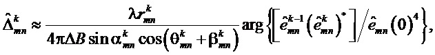
where λ is the SAR transmitter wavelength;  ,
,  ,
,  ,
,  – range, azimuth, elevation angle and angle to mn resolution element of radar image in k-th measurement session, respectively; ΔB is the distance between paired observation sessions;
 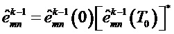 and
and 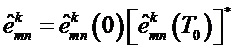 ,
, 


 are estimating the complex reflection coefficient – the complex pixel value in the radar image frame for the mn radar image resolution element in the k-th dimension of the first radar image pair and the second radar image pair, respectively; k=1K, K is the number of measurements, each of which consists of four sessions of two paired observation sessions with basic parameter B0 and ΔB between pairs.
EFFECT: high efficiency and accuracy of obtaining information in one pass of the SAR carrier, as well as simple measurement system.
1 cl, 1 dwg
| Title | Year | Author | Number |
|---|---|---|---|
| METHOD OF EARTH SURFACE RELIEF MEASUREMENT | 2016 |
|
RU2643790C1 |
| METHOD OF DETERMINING TERRAIN ELEVATION HEIGHT OF A RADAR WITH SYNTHESIZED ANTENNA APERTURE | 2019 |
|
RU2707556C1 |
| METHOD FOR GENERATING IMAGE OF THE GROUND SURFACE IN RADAR STATION WITH ANTENNA APERTURE SYNTHESIS | 2016 |
|
RU2614041C1 |
| METHOD OF INCREASING ANGULAR RADAR RESOLUTION DURING ANTEROLATERAL SCANNING | 2009 |
|
RU2416809C1 |
| METHOD FOR FRONTAL EARTH SURFACE APERTURE SYNTHESIS WITH EXCLUSION OF BLIND ZONES IN FRONT ZONE USING MULTI-POSITION RADAR SYSTEM | 2014 |
|
RU2560082C2 |
| GROUND MAPPING METHOD USING ON-BOARD RADAR SET | 2013 |
|
RU2529523C1 |
| METHOD FOR DETECTING AND DETERMINING COORDINATES OF SEARCH OBJECT | 2008 |
|
RU2392635C2 |
| METHOD FOR MEASUREMENT OF EFFECTIVE DISPERSION AREA OF GROUND OBJECTS BY RADAR WITH SYNTHESIZED ANTENNA APERTURE | 2006 |
|
RU2308050C1 |
| METHOD TO PROCESS SIGNALS OF COHERENT-PULSE SIDE-LOOKING RADAR | 2002 |
|
RU2229728C1 |
| METHOD OF OPTIMUM IMAGES RECONSTRUCTION IN RADAR LOCATION SYSTEMS OF EARTH'S REMOTE SENSING IN THE TELESCOPIC MODE | 2016 |
|
RU2618088C1 |

